Move nodes on maps
There are several possibilities to move nodes in gep-spatial environment.
This is of course the easiest way:
all data about the map is ignored.
This strategy makes sense if you need a geo-spatial coordinate system,
but you are simulating objects that are mostly or entirely unaffected by the street-level structure
(buildings, roads, etc.);
for instance, if the simulation involves unmanned aerial vehicles.
There is no need of importing actual map data when navigating this way.
This kind of navigation can be realized using
MoveToTarget.
Examples
Click to show / hide code
incarnation: protelis
variables:
  seed: &seed # You can give the anchor any name, assigning the name of the variable is convenient, though
    {min: 0, max: 1, step: 1, default: 0} # This variable ranges in [0, 9], steps of 1, defaulting to 0
network-model: { type: ConnectWithinDistance, parameters: [10] }
_program-pools:
  compute-gradient: &gradient
    - { time-distribution: 1, program: "advanced:converge" }
    - program: send
  move: &move
    - time-distribution: { type: ExponentialTime, parameters: [1] }
      type: Event
      actions: { type: MoveToTarget, parameters: [destination, 1] }
deployments: { type: Circle, parameters: [50, 0, 0, 5], programs: [*gradient, *move] }
terminate: { type: AfterTime, parameters: [20] }
Click to show / hide code
incarnation: protelis

variables:
  time: &time
    type: Flag
    parameters: [false]
  small: &small
    type: Flag
    parameters: [false]
  n: &n
    formula: 100
  range: &range
    formula: 30
  width: &w
    formula: 200
  height: &h
    formula: 20
  freq: &freq
    formula: 1
  sp:
    formula: 0.1
  bp:
    formula: 0.5
  retain: &retain
    formula: 1 / minfreq
  fc:
    formula: "time ? (small ? sp : bp) : 0"
  minfreq: &minfreq
    formula: "freq * (1 - fc)"
  maxfreq: &maxfreq
    formula: "freq * (1 + fc)"
  speed: &speed
    language: kotlin
    formula: "if (time as Boolean) 0 else 1"
  seed: &seed
    min: 0
    max: 199
    step: 1
    default: 0

seeds:
  scenario: *seed
  simulation: *seed

network-model:
  type: ConnectWithinDistance
  parameters: [*range]

_pools:
  - pool: &program
    - time-distribution:
        type: RandomDiracComb
        parameters: [*minfreq, *maxfreq]
      type: Event
      actions:
        - type: RunProtelisProgram
          parameters: ["1", *retain]
    - time-distribution: null
      program: send
  - pool: &program2
    - time-distribution: 1
      program: tomacs
    - time-distribution: null
      program: send
  - pool: &move
    - time-distribution: 10
      type: Event
      actions:
        - type: MoveToTarget
          parameters: [target, *speed]

deployments:
  - type: Rectangle
    parameters: [*n, 0, 0, *w, *h]
    contents:
      - molecule: time
        concentration: *time
      - molecule: speed
        concentration: *speed
      - molecule: small
        concentration: *small
    programs:
      - *program
      - *move
From the showcase
Optimal resilient distributed data collection in mobile edge environments
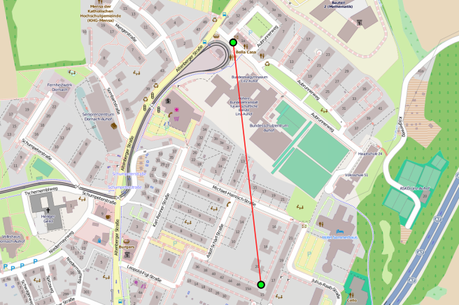
Navigate along the streets
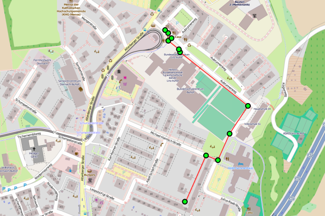
Moves along the available paths, depending on the specific vehicle being used.
Requires actual geo-spatial information.
This kind of navigation can be realized using
TargetMapWalker.
Reproduce a GPS Trace
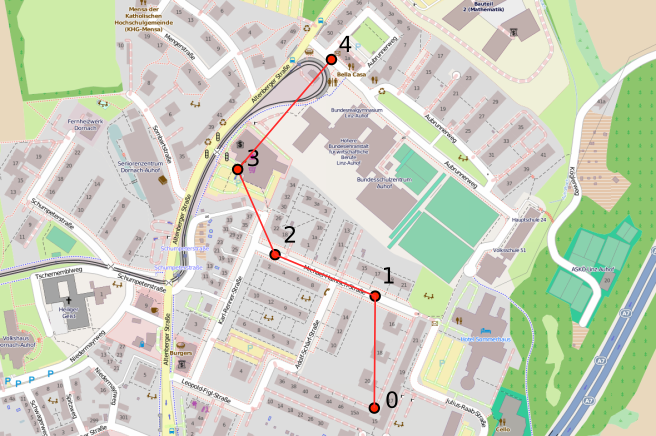
Ignores the map geospatial information and relies on a GPS trace instead,
starting from its first position and reaching the last,
navigating from point to point in “straight lines”
(on maps, these are actually orthodromes).
This kind of navigation can be realized using
ReproduceGPSTrace.
Deploying nodes using GPS traces
You probably want your nodes to start from the position that marks the beggining of a trace.
We discussed how to do so here.
Time alignment of GPS traces
Navigation with GPS traces usually require that they get correctly aligned with time,
especially if they come from samples taken at different times.
We discussed the alignment of GPS traces here,
the same alignment system used for importing traces is used for using them during navigation.
Examples
Click to show / hide code
environment:
  type: OSMEnvironment
  parameters: ["vcm.pbf", false] # Requires the file vcm.pbf in the classpath!

incarnation: sapere

_pools:
  - pool: &move
    - time-distribution: 0.1
      type: Event
      actions:
        - type: ReproduceGPSTrace
          parameters: ["gpsTrace", true, "AlignToSimulationTime"]

deployments:
  - type: FromGPSTrace
    parameters: [7, "gpsTrace", true, "AlignToSimulationTime"]
    programs:
      - *move

terminate:
  type: StableForSteps
  parameters:
    equalIntervals: 5
    checkInterval: 100
Interpolate GPS traces with street data
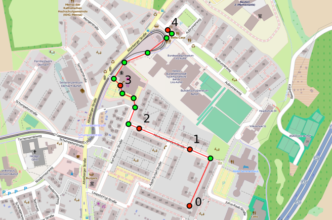
Navigates along a GPS trace, but computes the point-to-point distance using the navigation system,
rather than “straight lines” (orthodromes).
This kind of navigation can be realized using
GPSTraceWalker.