Find paths indoors
The background regarding the navigation system is explained here.
Generating navigation graphs from images
If your environment is codified as an image, generating a navigation graph is straight-forward. All you have to do is mark the areas of the environment where to plant initial seeds in blue (RGB #0000FF). In the image below you can see the generation of a navigation graph. The blue regions in the original image indicate where to plant initial seeds. These are then grown and crossings are found between them.
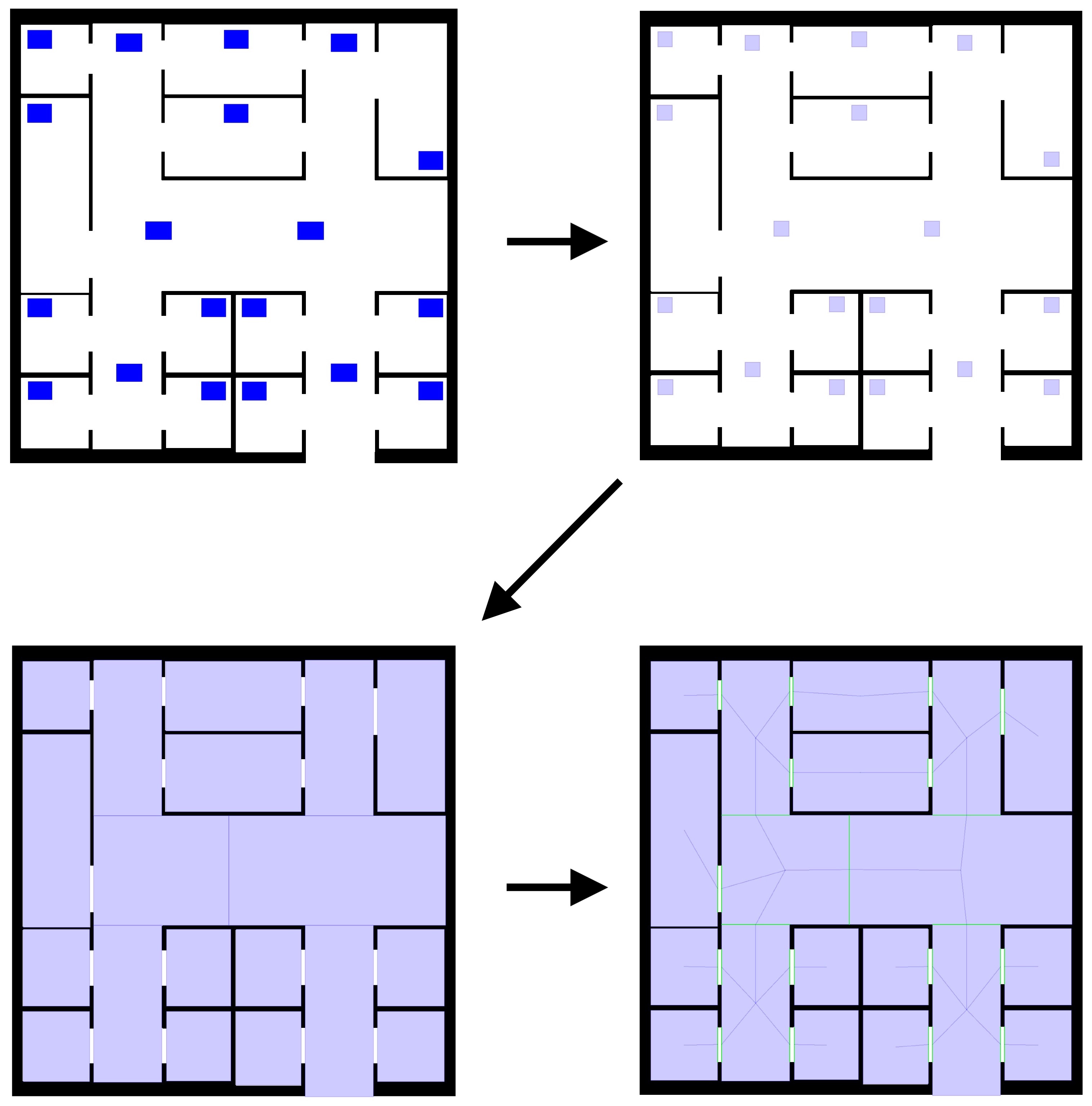
Once you have your image ready for the generation of the navigation graph, you can exploit the
ImageEnvironmentWithGraph class to produce it for you.
This will read your image, extract the positions you marked blue and pass them to the NaviGator algorithm.
Examples
Click to show / hide code
incarnation: protelis

environment:
  type: ImageEnvironmentWithGraph
  parameters: [images/building-planimetry.png, 0.1]

seeds:
  scenario: 0
  simulation: 1

_reactions: &behavior
  - time-distribution:
      type: DiracComb
      parameters: [3.0]
    type: PrioritySteering
    actions:
      - type: CognitiveAgentReachDestination
        parameters: [135, 15]

deployments:
  - type: Point
    parameters: [15, 15]
    capabilities:
      - type: CircularArea
      - type: Orienting2D
        parameters: [1.0]
      - type: Pedestrian
      - type: Social
    programs:
      - *behavior
Click to show / hide code
incarnation: protelis

environment:
  type: ImageEnvironmentWithGraph
  parameters: [images/congestion-avoidance.png, 0.1]

seeds:
  scenario: 0
  simulation: 2

_reactions: &behavior
  - time-distribution:
      type: DiracComb
      parameters: [1.0]
    type: PrioritySteering
    actions:
      - type: CognitiveAgentReachKnownDestination
        parameters: [10, 55]

deployments:
  - type: Point
    parameters: [70, 50]
    capabilities:
      - type: CircularArea
      - type: Orienting2D
        parameters: [1.0]
      - type: Pedestrian
      - type: Social
    programs:
      - *behavior
  - type: Grid
    parameters: [27, 52, 56, 58, 0.5, 0.5, 0.3, 0.3]
    capabilities:
      - type: Pedestrian
      - type: Perceptive2D
      - type: CircularArea
      - type: Social
  - type: Grid
    parameters: [30, 40, 50, 45, 0.5, 0.5, 0.3, 0.3]
    capabilities:
      - type: Pedestrian
      - type: Perceptive2D
      - type: CircularArea
      - type: Social
Click to show / hide code
incarnation: protelis

environment:
  type: ImageEnvironmentWithGraph
  parameters: [images/building-planimetry.png, 0.1]

seeds:
  scenario: 0
  simulation: 1

_reactions: &behavior
  - time-distribution:
      type: DiracComb
      parameters: [3.0]
    type: PrioritySteering
    actions:
      - type: CognitiveAgentExplore

deployments:
  - type: Point
    parameters: [15, 15]
    capabilities:
      - type: CircularArea
      - type: Orienting2D
        parameters: [0.0]
      - type: Pedestrian
      - type: Social
    programs:
      - *behavior
Click to show / hide code
incarnation: protelis

environment:
  type: ImageEnvironmentWithGraph
  parameters: [images/building-planimetry.png, 0.1]

seeds:
  scenario: 0
  simulation: 1

_reactions: &behavior
  - time-distribution:
      type: DiracComb
      parameters: [3.0]
    type: PrioritySteering
    actions:
      - type: CognitiveAgentFollowRoute
        parameters: [40, 15, 60, 80, 70, 105, 85, 80]

deployments:
  type: Point
  parameters: [15, 15]
  capabilities:
    - type: CircularArea
    - type: Orienting2D
      parameters: [0.0]
    - type: Pedestrian
    - type: Social
  programs: *behavior
Click to show / hide code
incarnation: protelis

environment:
  type: ImageEnvironmentWithGraph
  parameters: [images/congestion-avoidance.png, 0.1, 12, 60]

seeds:
  scenario: 0
  simulation: 2

_reactions: &behavior
  - time-distribution:
      type: DiracComb
      parameters: [1.0]
    type: OrientingBehavior2D

deployments:
  - type: Circle
    parameters: [130, 70, 52, 5]
    nodes:
      type: HomogeneousOrientingPedestrian2D
      parameters: [1.0]
    programs:
      - *behavior
  - type: Grid
    parameters: [27, 52, 56, 58, 0.5, 0.5, 0.3, 0.3]
    nodes:
      type: HomogeneousPedestrian2D
  - type: Grid
    parameters: [30, 40, 50, 45, 0.5, 0.5, 0.3, 0.3]
    nodes:
      type: HomogeneousPedestrian2D
Click to show / hide code
incarnation: protelis

environment:
  type: ImageEnvironmentWithGraph
  parameters: [images/building-planimetry.png, 0.1]

seeds:
  scenario: 0
  simulation: 1

_reactions: &behavior
  - time-distribution:
      type: DiracComb
      parameters: [3.0]
    type: PrioritySteering
    actions:
      - type: CognitiveAgentReachDestination
        parameters: [103, 99]
        # destination is unknown as pedestrian's cognitive map is empty

deployments:
  - type: Point
    parameters: [108, 88]
    capabilities:
      - type: CircularArea
      - type: Orienting2D
        parameters: [0.0]
      - type: Pedestrian
      - type: Social
    programs:
      - *behavior
Click to show / hide code
incarnation: protelis

environment:
  type: ImageEnvironmentWithGraph
  parameters: [images/building-planimetry.png, 0.1]

seeds:
  scenario: 0
  simulation: 1

_reactions: &behavior
  - time-distribution:
      type: DiracComb
      parameters: [3.0]
    type: PrioritySteering
    actions:
      - type: CognitiveAgentReachDestination
        parameters: [135, 15]
        # destination is unknown as pedestrian's cognitive map is empty

deployments:
  - type: Point
    parameters: [15, 15]
    capabilities:
      - type: CircularArea
      - type: Orienting2D
        parameters: [0.0]
      - type: Pedestrian
      - type: Social
    programs:
      - *behavior
Click to show / hide code
incarnation: protelis

environment:
  type: ImageEnvironmentWithGraph
  parameters: [images/building-planimetry.png, 0.1]

seeds:
  scenario: 0
  simulation: 4

_reactions: &behavior
  - time-distribution:
      type: DiracComb
      parameters: [3.0]
    type: PrioritySteering
    actions:
      - type: CognitiveAgentReachKnownDestination
        parameters: [135, 15]

deployments:
  - type: Point
    parameters: [15, 15]
    capabilities:
      - type: CircularArea
      - type: Orienting2D
        parameters: [0.3]
      - type: Pedestrian
      - type: Social
    programs:
      - *behavior
Click to show / hide code
incarnation: protelis

environment:
  type: ImageEnvironmentWithGraph
  parameters: [images/building-planimetry.png, 0.1]

seeds:
  scenario: 0
  simulation: 1

_reactions: &behavior
  - time-distribution:
      type: DiracComb
      parameters: [3.0]
    type: PrioritySteering
    actions:
      - type: CognitiveAgentPursue
        parameters: [135, 15]
        # Pursuing assumes the destination is known (despite the pedestrian's cognitive map is empty)

deployments:
  type: Point
  parameters: [15, 15]
  capabilities:
    - type: CircularArea
    - type: Orienting2D
      parameters: [0.0]
    - type: Pedestrian
    - type: Social
  programs: *behavior
Click to show / hide code
incarnation: protelis

environment:
  type: ImageEnvironmentWithGraph
  parameters: [images/building-planimetry.png, 0.1]

seeds:
  scenario: 0
  simulation: 1

_reactions: &behavior
  - time-distribution:
      type: DiracComb
      parameters: [3.0]
    type: PrioritySteering
    actions:
      - type: CognitiveAgentReachDestination
        parameters: [60, 40, 85, 15]
        # (85, 15) will be known, (60, 40) won't be known but will be reached because found along the way to the former

deployments:
  - type: Point
    parameters: [15, 15]
    capabilities:
      - type: CircularArea
      - type: Orienting2D
        parameters: [0.4]
      - type: Pedestrian
      - type: Social
    programs:
      - *behavior
Click to show / hide code
incarnation: protelis

environment:
  type: ImageEnvironmentWithGraph
  parameters:
    path: planimetry.png
    zoom: 0.05

_reactions: &behavior
  - time-distribution:
      type: DiracComb
      parameters: [1.0]
    type: CognitiveBehavior

deployments:
  - type: Point
    parameters: [2, 2]
    capabilities:
      - type: Human
        parameters: ["adult", "male"]
      - type: Perceptive2D
      - type: CognitivePedestrian
      - type: Cognitive2D
      - type: Orienting2D
        parameters: [0.5]
    programs:
      - *behavior
Click to show / hide code
incarnation: protelis

environment:
  type: ImageEnvironmentWithGraph
  parameters:
    path: planimetry.png
    zoom: 0.05

deployments:
  - type: Point
    parameters: [2, 2]
    capabilities:
      - type: Pedestrian
      - type: CircularArea
      - type: Orienting2D
        parameters: [0.5]
Click to show / hide code
incarnation: protelis

environment:
  type: EnvironmentWithDynamics
  parameters:
    path: planimetry.png
    zoom: 0.05

deployments:
  - type: Point
    parameters: [2, 2]
    capabilities:
      - type: Pedestrian
      - type: PhysicalPedestrian2D
      - type: Perceptive2D
      - type: CircularArea
      - type: Social
    programs:
      - time-distribution:
          type: DiracComb
          parameters: [1.0]
        type: PhysicalBlendedSteering
        actions:
          - type: CognitiveAgentSeek
            parameters: [1000, 500]
          - type: CognitiveAgentFlee
            parameters: [500, -500]